Geothermal Education Office

GEOTHERMAL ENERGY - Worldwide
World Map with Links

Glossary of Map Page Terms

ENERGY UNITS

GWh - gigawatt hour thermal. A unit of heat energy for non-electrical uses equal to 1000 megawatt hours (MWh).

A GWh can heat 860 thousand tons of water one degree centigrade (or bring about 9 million quarts of freezing water to a boil).

MWe - megawatt electrical. A unit of electrical power equal to 1000 kilowatts (kWe) - enough (in the U.S) for about 1000 people.

Additional Glossary Items...

  1. Russia
  2. Japan
  3. Eastern China
  4. Himalayan Geothermal Belt
  5. The Philippines
  6. Indonesia
  1. New Zealand
  2. Canada
  3. United States
  4. Mexico
  5. Central American Volcanic Belt
  6. Andean Volcanic Belt
  1. The Caribbean
  2. Iceland and other Atlantic Islands
  3. Northern Europe
  4. Eastern Europe
  5. Italy
  6. Eastern and Southern Mediterranean
  7. East Africa Rift System
Additional Glossary Items Energy Unit Glossary...

Aquifer - a porous or fractured body of rock carrying cold or hot water.

Basin or Sedimentary basin - a bowl-shaped depression in the earth filled with sedimentary rocks (rocks usually formed in water such as sandstone, limestone, etc.).

Fault - a break in the earth's crust which extends a considerable distance (horizontally and vertically) along which relative (sliding) movement occurs.

Fumarole - a flow of steam from the ground. Fumaroles can be weak or strong, noisy and superheated (temperature above boiling).

Hot spot - a relatively small area of a plate heated by a rising plume of magma from deep within the mantle which produces local volcanic activity over a long time period.
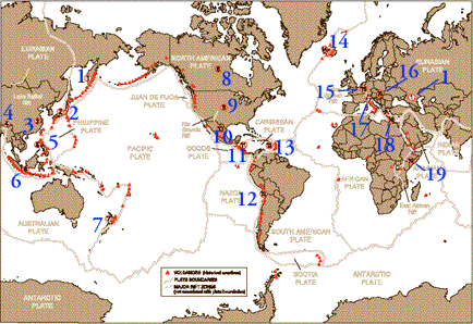
Plate - a rigid part of the earth's crust that moves relative to other plates. The map shows eight major plates and several minor ones.

Plate boundary - where two plates meet. When plates move apart they form a rift boundary (e.g. the North American and Eurasian plates). When they move together they can bump to form a collision boundary (e.g. the Indian and Eurasian plates) or one can slide under the other to form a subduction boundary (e.g. the Nazca and South American plates). Sometimes plates just slide past each other along a fault boundary (e.g. the San Andreas fault between the North American and Pacific Plates). Some boundaries (e.g. through Siberia) are poorly defined.

Rift - a part of the crust that has been pulled apart, usually bordered by faults. A rift zone is a rift with bordering faults. When rifting occurs, magma can move near the surface, forming volcanoes and geothermal systems. Rift zones may become plate boundaries.

Sinter - a white or gray surface deposit from a hot spring or geyser consisting of silica (SiO2). Travertine is a similar deposit consisting of carbonate (usually CaCO3).

Contributors: Research and text by Alfred Truesdell. Concept and additional text by Marilyn Nemzer (Geothermal Education Office). Base map by Ellen Lougee (U.S. Geological Survey) using plate boundaries from Charles DeMets (U.Wisc.). Locations of volcanoes with historical eruptions by Robert Tilling (USGS). Most energy production figures (MWe and GWh/yr) are from articles by G.W. Huttrer and D.H. Freeston in the 1995 World Geothermal Congress Proceedings. Further information is from U.N. Conferences on Geothermal Energy in 1970, and 1975, and GRC International Meetings in 1985 and 1990. The authors appreciate the data and good advice from Marnell Dickson (IIRG), John Lund (GHC), Patrick Muffler (USGS), Marcelo Lippmann (LBL), and numerous readers of the earlier printings.

All readers are invited to keep the GEO informed of projects in their countries.


© 1997 - 2000 Geothermal Education Office